Westport in Brief!
EverythingWestport.com
Wednesday, August 31, 2011
Quick Article Index . . .
An irate Irene slaps Westport.
|
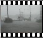
EverythingWestport.com Saturday, August 27, 2011 Is hurricane Irene overblown? Storm forecasts continue to show a
tropical storm on the decline as winds weaken and predictions of rain in
Westport are now between two and six inches, less as you move out onto the
Cape and Islands. Sunday wind speeds
have been downgraded to gusts up to 65 knots, and seas in Buzzard's Bay
between six and eight feet. The big story now
with Irene is the potential for a storm surge that could flood coastal waters
and low-lying areas, depending on a race condition between the storm's speed
and expected arrival on Sunday, and tomorrow morning's high tide. The harbormaster's
office has not issued any warnings except to stay off the water, and the
harbor mouth is still open, although not advisable to navigate. Surf's up on East
Beach, and the ubiquitous surfers are already testing their abilities as wave
height increases. The DCR has closed Horseneck Beach and evacuated all
trailers from the campground, and Westport has closed all town beaches and
evacuated all trailers from East Beach. The storm's track has moved slightly to the east, putting Westport back into the outer fringes of Irene's eye. An irate Irene slaps Westport. EverythingWestport.com Monday, August 29, 2011 Click here for exclusive storm photos.
Like a cheap
dime store novel, Irene blew into town, broke a few hearts, and took the first bus out
of town leaving a mess for the rest of us to clean up. You gotta hate a hurricane. The tropical storm that would be a hurricane spared the flood but
spoiled the roadways, decorating them with copious amounts of twigs, branches,
entire limbs, and more than just a few trees.
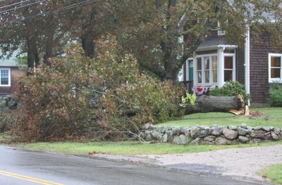
Above: Westport's canopy was thinned by Irene. Felled trees at (left)
Alden Hill Real Estate on Main Road in Central Village, and (right) a huge
tree completely blocked Main Road at the intersection of Charlotte White
Road. Downgraded to a tropical storm from her skirmish with new England's
coastline, a weakened Irene took out her fury on Westport, lashing the town's
coastline with 65 knot winds and occasional pelting rain, eroding beaches, punching
through some barrier dunes, and in the process destroying much of East Beach
Road leaving many campers homeless. Westport's canopy of trees was thinned a bit by the unrepentant Irene,
and over 100 trees had to be cleared from roadways, according to Highway
Surveyor Jack Sisson. "And that didn't include any trees that fell on
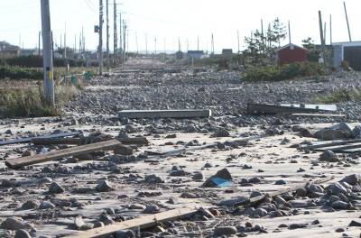
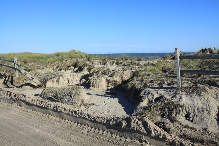
electrical wires," Sisson said. East Beach Road took a big hit, leaving the oft bedeviled shore road impassable,
littered with walkways, sheds, cinder blocks and rocks, and slimed with mud
and sand. Click
here for exclusive photos of East Beach Road. As a finishing touch, the street was blanketed with the ubiquitous
cobblestones. A large, weighty sea turtle, exhausted by the strong surf and
tides, lost its way and expired on the shattered asphalt surface.
Phone poles were down and as much as 50 feet of beach front was lost
to erosion, leaving some summer campers scratching their heads as to where
their trailers will go next. The seasonal residents were evacuated by Saturday, the trailers being
hauled off days before up Horseneck Road for safe storage on local farmland. Most never expected they might never return. No flooding, but
lots of wind damage. Westport was spared the heavy rains that caused the expansive flooding
experienced by its western neighbors. Central Massachusetts, Rhode Island and Connecticut were hardest hit
with heavy rains that for the most part missed Westport, which received scant
flooding. Forge Road and Adamsville Road dams were never threatened, and there
was no flooding on area roadways from storm water runoff. Atlantic Avenue to the west of the harbor took a savage beating
according to Richie Earle, Westport Harbormaster. "The storm punched through
sections of the dunes and pushed a lot of sand up onto the road and abutters'
property," Earle said. The road resembled a winter scene with the sand plowed back like heavy
snow drifts.
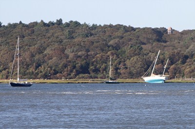
Three sailboats, one over 40 feet, broke moorings and ended up in the
West Branch marshes according to Earle. "One other powerboat joined them," Earle said. "We also
lost a pontoon boat in the East Branch but it was recovered pretty
quickly." "Another 26 foot powerboat was driven up onto Gooseberry Island
by a Connecticut couple trying to beat the storm into Westport Harbor late
Saturday," Earle said. "We rescued the man and his wife, but had to
leave the boat there until we could take a look at it today." Seas in Rhode Island Sound were forecast around 10 feet Saturday
night, increasing to 20 feet Sunday morning and then building to 26 feet in
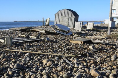
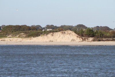
the afternoon. Not good conditions for a small power craft. "The beaches and dunes really took a beating from the town beach
to Horseneck Point," Earle said. A
large section of barrier dunes was cut away, especially on "boaters' beach,"
creating sand cliffs as high as 30 feet. "A lot of sand was carried
away,' Earle said.
Above: The storm surge broke through the dunes on Atlantic Avenue and
flooded the picturesque lane with tons of sand. Click here for exclusive storm aftermath photos. - - - - - End - - - - - ©
2011 Community Events of Westport
All rights reserved. EverythingWestport.com |
|
|