Westport in Brief!
EverythingWestport.com
Sunday, November 6, 2016
photos/EverythingWestport.com except as
noted
Roots of Cuffe family legacy are
revealed at WHS lecture.
|
Roots of Cuffe family legacy are revealed at WHS
lecture. Painstaking research by highly experienced historians solves
ages-old mystery. EverythingWestport.com Saturday, November 5, 2016 Photos | EverythingWestport.com
Special Correspondent to
EverythingWestport.com WESTPORT
– For years, local historians have been trying to pinpoint the exact location
of the riverside home and commercial wharf where world-renowned Quaker
businessman and philanthropist Paul Cuffe lived and
managed his fleet of merchant ships and whalers. The long quest ended earlier
this year, when researchers finally confirmed that a tiny plot of land off
Drift Road was the starting point of the commercial empire that spanned the
globe by the start of the 19th century. The
shipbuilding and maritime trading empire started in Westport made Cuffe perhaps the richest man of African and Native
American descent in the entire country in the early 1800s.
Three local history buffs provided the details of that multi-year search for Cuffe’s land holdings on the East Branch of the Westport
River, south of Hix Bridge, at a Nov. 4 illustrated
talk hosted by the Westport Historical Society. Today,
the quarter-acre homestead where Cuffe once lived
and worked is located at the end of the private drive leading to a waterfront
home at 1436 Drift Road, owned by a member of the Lafrance
family. Additional parcels of land in the neighborhood purchased over the
years by Cuffe and his relations were also
positively identified, along with the Old County Road property owned by his
father and later inherited by Cuffe and his
brother.
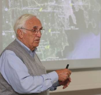
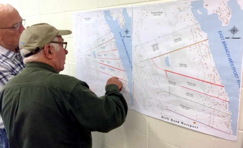
Inset: David Cole of Westport Point guides
the audience along the historical research trail leading to the exact
location of the original Cuffe homestead. The
painstaking research reviewed at the lecture went well beyond a narrow focus
on Cuffe’s local real estate holdings, as indicated
by the talk’s formal title: The Remarkable African and Native American Legacy
of Cuff Slocum and Ruth Moses, As Seen Through Their Properties. Slocum
was a black slave who had purchased his freedom from his Dartmouth owner in
1744; Moses was a Wampanoag woman from Martha’s Vineyard. Despite the
considerable racial prejudice of the era, their children and in-laws became respected
members of the community and ended up owning considerable amounts of property
in their adopted hometown of Westport. Paul Cuffe became the most famous member of the family,
starting his maritime career as a crewman aboard a New Bedford whaleship, and
building a successful career as a coastal trader, shipbuilder and ship's
captain who was welcomed into the Society of Friends and established the town’s
first free school, serving children of all races. He was an advocate for the
rights of free African-Americans in his youth, and was later known as an
active supporter of the effort to return free slaves to their African
homelands. Slade
started the story of the local legacy of the family of Cuff Slocum and his
wife with an explanation of the research process, aimed at solving the “mysteries”
about the extended family that had puzzled historians for many years. She
said the trio of researchers had delved deep into old deeds and maps, wills
and probate records, and various property tax lists that eventually
pinpointed the properties owned by Slocum, Cuffe,
and Cuffe’s brother-in-law and business partner,
Michael Wainer. The
1798 federal direct tax records for Westport turned out to be the document
that definitively identified Cuffe’s home and wharf
off Drift Road, as it listed all properties and values in the neighborhood in
an orderly fashion from north to south. A similar process located the Cuff
Slocum property at present-day 761 Old County Road; local census records then
identified exactly who was living on those properties in 1790 and 1810, Slade
said. No
trace of either the original Slocum home near Fisher Road, nor the Cuffe house on the East Branch remain, she noted. Off
Drift Road, “Paul Cuffe’s homestead and Michael Wainer’s homestead are identified accurately” on old maps
overlaid onto modern GIS maps of the area, she explained. The
research was unable to pinpoint the riverfront site across from the point of
Cadman’s Neck where Cuffe built and launched his
commercial vessels, ranging from catboats and small schooners in the early
days, to larger vessels later used for trading with the West Indies and
foreign ports. Cole
started the history lesson on the family legacy by noting, “We wanted to
start with Cuff Slocum and his wife Ruth Moses because they were the
progenitors of all these subsequent people” studied in the lengthy research
project. The
best guess is that Cuff Slocum was born circa 1717 in West Africa, possibly
modern-day Ghana, and sold into slavery as a youth. He landed in Newport,
Rhode Island in 1728, and was bought by Ebenezer Slocum of Dartmouth, a
well-to-do ship’s captain who owned other slaves, Cole indicated. As was
the custom of the time, Slocum gave the slave Cuff his own surname. After 14
years, he sold the adult slave to his nephew John, who allowed Cuff to buy
his freedom a short time later. Between
1742 and 1766, Cuff Slocum had married Ruth Moses, and was raising a family
while managing the Slocum family farm on Cuttyhunk
Island. In 1766, Slocum was somehow able to raise 650 Spanish dollars to purchase
116 acres off Old County Road in Dartmouth from David Brownell, and the
family relocated there the following year, Cole said. When
Slocum died in 1772, the property was divided between his youngest sons, John
and Paul Cuffe. They and others of the nine
children had given up the slave name Slocum, but a few, like sister Mary
Slocum, who would marry Michael Wainer, kept the
original family name, according to Gifford, an expert in genealogical studies. John inherited
the portion of the homestead near the Fisher Road intersection, while Paul got
the western half. The family home has been gone since the mid-1800s, but the homestead will soon be recognized by the
present owners by the dedication of the Cuff Slocum Clean Energy Collective
Solar Farm on the property, Cole noted. There
was no indication that young Paul Cuffe lived on
Old County Road, but research turned up the fact that he and his Wampanoag wife
Alice Pequot, who he married in 1783, lived on Fisher Road before moving to
Westport. Cole
said deed research indicated that when the Russells Farm on Fisher Road was
sold, a half-acre plot was excluded “for Paul Cuffe,
who is living in an Indian-style house” on Fisher Road near Destruction
Brook, probably with his new wife. Fortunes
were soon looking up for Cuffe, who had made some
money whaling and blockade-running supplies to the offshore islands By
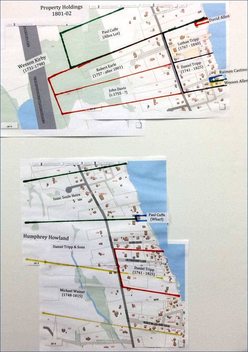
1789, Cuffe had prospered enough to purchase a .22 acre
lot on the East Branch from the Soule family, and soon built a house and
wharf there. He would purchase several additional parcels over the years,
eventually building up more than 100 acres of property along the river south
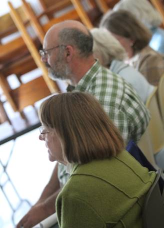
of Hix Bridge. Inset: Betty Slade (foreground and Richard
Gifford (center) listen to David Cole’s presentation. Though
the original parcel where Cuffe built was small, by
the time of the 1798 federal tax survey, the Cuffe
homestead “was one of about 15 houses in all of Westport that were valued at
more than $600,” Cole pointed out. A year
later, Cuffe bought the 100-acre Eddy Homestead to
the south of his homestead, and re-sold it to Wainer
and his sister, Mary, who moved to the site. Wainer, a Native American had previously lived in
Russells Mills with his first wife, Lydia Pequot, at the current site of Davoll’s General Store. Cole said Wainer
is believed to have operated the tannery on the nearby river that gave
Tannery Lane its name; the land at the corner of Russells Mills Road and
Tannery Lane was sold to Barnea Devol,
and as we know, came to be the site of Davoll’s
Store. After
marrying Mary Slocum, Wainer became a partner in
various Cuffe shipbuilding and trading ventures,
including a schooner named after Mary. As the family grew, “Many of those Wainer children were captains on Paul Cuffe
ships,” Cole said. Other
family members stayed on land, dealing with other family commercial ventures,
such as the Cuffe-Howards store in New Bedford,
which specialized in products imported from the West Indies, he noted. Other Cuffee properties turned up by the research team included
a parcel on the East Branch of the Westport River near the Town Farm, where Cuffe planned to build a saltworks
that was never completed. He also owned some salt meadows near the Let and
Horseneck Beach, and some property at Westport Point. Click
here to learn more about early saltworks in Massachusetts. After
his death in 1817, Cuffe’s estate also came into
possession of a “machine lot” near Forge Pond that contained several mills,
given as collateral for a loan that had not been paid off. His riverfront
property on the East Branch and other parcels of land were divided up among
his siblings and children. All of
the Slocum, Cuffe and Wainer
properties stretching from Westport to New Bedford, where a Paul Cuffe Park has been established in the waterfront
historic district, would make interesting stopping points along an African
and Native American heritage trail that the researchers would like to see
created some day, Cole said. “We’re
hoping to make some progress on that heritage trail” in coming years, he
noted. “Signs will be going up to mark these important sites,” and direct
people to a website detailing the complete history of the locations where Slocums, Cuffes and Wainers helped write the history of this place they
called home some 200 years ago.
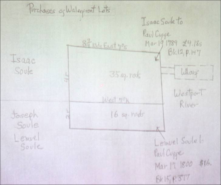
Above: Original plot plan recorded in the Registry of
Deeds.
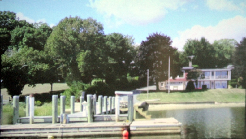
Above: Current picture of privately-owned
property formerly the original 1789 Cuffe homestead.
Above: Meeting guests review some of the study documents leading researchers
to find the exact location of the original Cuffe
homestead.
Above: Susan Waters, a Wampanoag born and raised in Dartmouth, learns more
about early Wampanoag relationships in Westport.
Above: Painstaking research into town records, early tax reports and recorded
deeds led researchers to identify the exact location of the Cuffe homestead and ship building business. © 2016 Community Events of Westport. All
rights reserved. EverythingWestport.com |